This
Afternoon

Chance Showers And TStorms
Hi 65°F
|
NWS forecast: A chance of showers and thunderstorms. Mostly cloudy. High near 65, with temperatures falling to around 63 in the afternoon. Southeast wind around 10 mph, with gusts as high as 18 mph. Chance of precipitation is 30%. New rainfall amounts between a quarter and half of an inch possible.
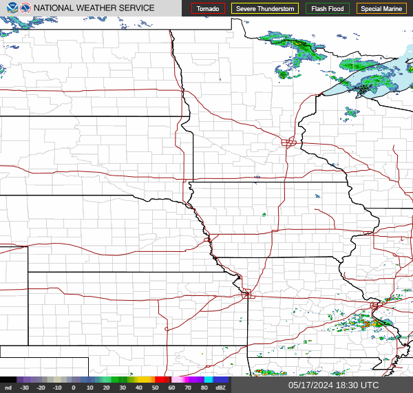
WXSIM forecast: Mostly cloudy to cloudy in the evening, becoming cloudy after midnight. Patchy light fog in the evening, then light to moderate fog after midnight. A chance of rain in the evening, then rain likely after midnight. Thunderstorms very likely, some severe. Low 58°. Wind south around 6 mph, gusting to 16 mph, in the evening, becoming north-northwest after midnight. Chance of precipitation 80 percent. Precipitation mostly around half an inch.
|
Tonight

Showers And TStorms Likely
Lo 55°F
|
NWS forecast: Showers and thunderstorms likely before 1am, then showers and thunderstorms between 1am and 5am, then a chance of showers and thunderstorms. Mostly cloudy. Low around 55, with temperatures rising to around 58 overnight. Southeast wind 6 to 9 mph, with gusts as high as 16 mph. Chance of precipitation is 80%. New rainfall amounts between three quarters and one inch possible.
WXSIM forecast: Mostly cloudy to cloudy. Light to moderate fog in the morning. A chance of rain in the morning, then a slight chance of rain in the afternoon. Thunderstorms very likely, some possibly severe. High 64°. UV index up to 5. Wind north-northwest around 5 mph, gusting to 18 mph, in the morning, becoming 14 mph, gusting to 25 mph, in the afternoon. Chance of precipitation 60 percent. Precipitation mostly less than a quarter of an inch.
|

 Scan With Phone's Bar Code Reader