64°F
^^
Top
Lincoln, NE USA
Updated:  09-May-2025 12:06 AM 
  Night time, Dry, Clear skies Temperature: 64.6°F Colder 2.6°F than last hour.   -2.6°F/hr Humidity: 52%Increased 4.0% since last hour. Dew Point: 46.6°FDecreased 0.3°F since last hour. Wind: ENE  0.4 mph Gust: 0.0 mph Barometer: 30.142 inHgRising 0.01  inHg/hr  Steady Rain Today: 0.00 in UV Index: 0.0  None

Navigation

  • Search SE Lincoln Wx
  • Home
  • Mini-Home
  • Quick Access Menu
    • US Ridge II Radars
    • GR3 Radar
    • NWS Forecast
    • NWS NE Point Forecasts
    • Local NWS Forecast
    • WXSIM Forecast
    • GOES19-18 HAniS Loops
    • GOES19 HAniS Loops
    • GOES18 HAniS Loops
    • Day 1-3 Fronts
    • 3 Day Storm Risk
    • QPF 3 Day Loops
    • QPF 3 Day Snow/Ice Loops
    • 3 Day Predicted Snowfall
    • Winter Storm Severity
    • 7 Day Forecast
    • WFO Stories
    • NWS WFO Text Products
    • EHWO from CRH
    • Excess Rain Potential
    • Storm Prediction Center
    • CPC Outlook
    • Earthquake activity Last 7 Days
    • Nearby METAR Station Reports
    • SE Nebraska River Levels
    • WPC River Flood Outlook
    • Lightning Past 2 Hours
    • Lincoln Live Traffic Cameras
    • SE Lincoln Wx. Precip. Graphs
    • US Drought Monitor
    • On This Day
    • World Extremes
  • Radar
    • US Ridge Radars
    • GR3 Radar
    • UCAR Local Radar
    • MRMS Viewer
    • US Radar Sites
    • More US Radar
      • WU US Radar
    • NWS Radar & Threats
      • WPC 6 Hr. Radar Analysis
  • Satellite Loops
    • Combined GOES E & W Color Loops
      • Color US 4 Hour Loop
      • Color US BIG 12 Hour Loop
    • GOES19-18 HAniS Loops
    • GOES19 HAniS Loops
    • GOES19 GIF Loops
    • GOES18 HAniS Loops
    • GOESWest GIF Loops
    • SSEC Global Basin Loops
    • SSEC Satellite Viewer
  • NOAA Radios
  • Recent Weather
    • Hourly Roundups
    • Recent Precipitation
      • US Precipitation Maps
      • Snowfall Maps
        • Current & Past Snowfall Measured
        • Current Snowfall Interpolated
        • Interactive Maps
      • Past 120 Days
    • Recent Local Data
      • Lincoln Airport Past 24 Hours
    • 24 Hour Temperature Changes
      • TWC US Map
    • EXPERIMENTAL NWS 24 Hour Changes
    • NE 4" Soil Temps
    • Storm Reports
      • National
      • Local
  • Snowfall Maps
    • 3 Day Predicted Snowfall
    • Current & Past Snowfall Measured
    • Current Snowfall Interpolated
    • Interactive Maps
  • Forecasts, Advisories, & Alerts
    • NWS Forecasts
      • NWS NE Point Forecasts
      • Local Forecasts
        • Text Forecast
        • Local NWS Forecast
        • Graphical Forecasts
      • US Front Maps
        • US Static
        • Day 1-3 Fronts/FC
        • Day 3-7 Fronts
        • US 3 & 7 Day Front Loops
      • US Forecast Maps
        • Day 3-7 WPC Forecasts
        • US Forecast Maps
        • Precipitation
          • 3 Day Forecast
          • QPF 3 Day Loops
          • 3 Day Freezing Precip. Loops
          • 3 Day Predicted Snowfall
          • 3 Day Freezing Precip.
          • 7 Day Forecast
          • 1-7 Day Loops
        • Lightning & Convection
        • Winter 3 Day Lows
        • 7 Day Temperatures
        • Combined Maps
        • US Forecast Loops
        • Regional Forecast Loops
      • Weather Stories
        • WFO Stories
        • CRH Stories Thumbnails
      • NDFD Display
    • WXSIM Forecast
      • wsWXSIM Forecast
      • WXSIM Text Forecast
      • Temps-WXSIM vs. NWS
    • Forecast Models
    • Snow Day Predictor
    • Jet Stream Forecasts
      • Weatherforyou
      • Stormsurfing
      • SFSU
      • Global Orthographic
    • NWS WFO Text Products
    • EHWO from CRH
    • Resized NWS US Advisory Map
    • NWS US Advisory Map
    • NWS Advisories
    • NWS Alerts
    • Fire Danger
      • Nebraska Wildfire Danger
      • NFS Nebraska Fire Danger
    • UV Index Forecast
  • NWS Weather Forecast Offices
    • EHWO from CRH
    • WFO Stories
    • NWS WFO Text Products
    • 3 Day Predicted Snowfall
    • Winter Storm Severity Index
  • NWS Centers
    • Weather Prediction Center
      • Current Hi-Rez Surface Analyses
      • Current 24 Hour Surface Analyses
      • Current 24 Hour Analysis Loops
      • Current 6 Hour Analysis Loop
      • US Forecast Maps
      • Day 1-3 Fronts
      • ½ to 2½ Day Forecast Loop
      • Day 3-7 Fronts
      • Day 3-7 WPC Forecasts
      • US 3 & 7 Day Front Loops
      • Precipitation
        • 3 Day Forecast
        • QPF 3 Day Loops
        • 3 Day Freezing Precip. Loops
        • 3 Day Freezing Precip.
        • 7 Day Forecast
        • Up To 7 Day Loops
        • 1-7 Day Loops
      • Excess Rain Potential
      • Winter Storm Severity
      • Winter 3 Day Lows
      • Winter Weather Verification
      • US 3-7 Day Loops
      • US 3-7 Day Heat Indices
      • NWS Experimental Heat Risk by State
      • River Flood Outlook
    • Storm Prediction Center
      • SPC Overview
      • 3 Day Storm Risk
      • Mesoanalysis
        • Mesoanalysis Maps & Links
        • Mesoanalysis Study Map
      • Storm Reports
      • Composite Map
      • HRRR Model Browser
      • Severe Weather Probabilities
        • Today & by Day
        • Loop for Year by Week
      • Tornado History
        • Fatal Tornado History
        • Tornado Environment Browser
      • Watch Summaries
        • Recent Severe Watch Summaries
        • Historical Watch Summaries
      • Past Daily Maps
      • Experimental Pages
        • Storm Opportunities
        • SREF
    • 'Climate' Prediction Center
      • CPC Outlook
      • Near-Term Outlook
      • Long-Term Outlook
      • Wind Chill Outlook
    • Hurricane Center
      • Atlantic Region
      • Pacific Region
    • Meteorological Development Laboratory
      • LAMP 24 Hour Forecast Maps
    • NSSL Op Product Viewer
    • NWS Enhanced Data Display
    • Environmental Lab
      • Environmental View
    • NDFD Display
  • Wind & Forecast Charts
    • Wind & Forecasts
    • Ventusky Charts
  • River Levels
    • Local
    • SE Nebraska
    • Nebraska
    • Missouri Basin
    • US
    • WPC River Flood Outlook
  • Astronomy
    • Sun Stars Space
    • Space Weather
      • Insight's Mars Weather
      • Space Weather
      • Alternate Space Weather
      • NASA Solar Wind Prediction
      • NASA Aurora Borealis Prediction
    • Sun Moon Earth
      • Brief Sun-Moon Almanac
      • Detailed Sun-Moon-Earth Almanac
  • Almanac
    • Current Trends
    • Station Graphs
    • Station Monthly Reports by Day
    • Avalance Danger
    • Earthquake activity
      • Last 7 Days
      • Global Realtime
    • Volcano Activity
    • Nearby METAR Reports
    • NASA IOD
    • Weather Extremes
  • WebCam
    • HikVision PatioCam
    • Streaming via Webcam 7
  • More Live Weather
    • Weather34
    • Steelseries Gauges
    • VP2 Console
    • WD Live Here
    • WD Live
  • Lightning
    • Live Lightning
      • Blitzortung
        • Live
        • Blitzortung Past 2 Hours
        • Vector-Based Map
    • 24 Hour Forecast Lightning & Convection
    • Blitzortung USA
    • GOES-16 Plots
    • US Death Hx Map 1996-2014
  • Travel & Road Conditions
    • Roads
      • Local Roads
        • Live Lincoln Traffic Cameras (Firefox Blocks!)
          • Auto-Rotating
          • Non-Rotating
        • Street Closures
        • Lincoln Traffic Map
      • NE Road Conditions
        • NE Roads
        • NE Road Snow Plows
      • US Roads
    • Air Travel
      • Flight Delays
      • FlightAware Map
      • Flight Tracker Map
  • Station History
    • Hi-Lo-Avg
    • Tabular Details
    • Freeze Data
    • Station Records
      • Daily Records per Month
      • All Time Records
      • Records for Year
      • Records for Month
    • Graphical Summaries
    • Graphs
  • Weather Underground WxHx
  • Weather Trends
    • Local Temperature Trends
    • Local Rain & Temperature Trends
    • Local Rainfal Trends
  • Mesonets
    • UNL Nebraska Mesonet
    • Plains Weather Network
    • Global Mesonets
  • Area Mesomaps
    • WU Mesomap+
    • NWS Mesomap
  • Drought Pages
    • US Drought Monitor
    • Animated Maps
    • Indicator Map
    • CPC Outlook
    • NISDIS Drought Portal
    • USGS Water Watch
    • USGS Water Watch 7 Day
  • NASA Image of the Day
  • World Extremes
  • On This Day
  • US Flu Maps
  • Air Quality
    • US Air Quality
    • Fire and Smoke
  • Pollen
    • Lincoln (NWU & Allergy & Asthma Associates)
      • Lincoln Pollen Count Summaries
  • Links
  • About
  • Site Status
    • Check I
    • Check II
    • Check III
  • Contact
  • Website Map
  • Mobile Pages
    • WWL-Mobile
    • Cell - 6 Pages

Alerts


No alerts

Mobile Weather

Get SE LincolnWx SmartPhone Weather QRCode2Scan With Phone's Bar Code Reader

US Weather Extremes

==========
USA
High Temp
99°F at Faith Ranch Airport, TX
Low Temp
15°F at Angel Fire Airport, NM
Precipitation
3.26in at Abbeville Chris Crusta Memorial Airport, LA
==========

NE Weather Extremes

==========
NE
for Wednesday,
May 7, 2025
High Temp
82°F at Tekamah Municipal Ap, NE
Low Temp
41°F at Echo (pine Bluffs), NE
41°F at Chadron Municipal Ap, NE
Precipitation
0.48in at Broken Bow Municipal Ap, NE
==========
Data from NWS CPC

External Links

  • Weather Underground
  • WXforum.net
  • Wx Display Forum
Other Links
  • Windows 7 Theme Packs
  • SE Lincoln Wx Scripts
  • Tuba-Euphonium Forum

Local Sunlight Hours

14 hrs 18 min 9 sec
of Sunlight Today
Which is
2 min 6 sec Longer
Than Yesterday
(Noon)
Day-Night Graphic
(Midnight)
LegendLegend

Style Options


Widescreen:
|

UNL and Climate Prediction Center Drought Monitors

Animated US Drought Maps


Drought Maps by State

United States 
Alabama
Alaska
Arizona
Arkansas
California
Colorado
Connecticut
Delaware
Florida
Georgia
Idaho
Hawaii
Illinois
Indiana
Iowa
Kansas
Kentucky
Louisiana
Maine
Maryland
Massachusetts
Michigan
Minnesota
Mississippi
Missouri
Montana
Nebraska
Nevada
New Hampshire
New Jersey
New Mexico
New York
North Carolina
North Dakota
Ohio
Oklahoma
Oregon
Pennsylvania
Rhode Island
South Carolina
South Dakota
Tennessee
Texas
Utah
Vermont
Virginia
Washington
West Virginia
Wisconsin
Wyoming
United_States Alabama Alaska Arizona Aransas California Colorado Connecticut Delaware Florida Georgia Hawaii Idaho Illinois Indiana Iowa Kansas Kentucky Louisiana Maine Maryland Massachusetts Michigan Minnesota Mississippi Missouri Montana Nebraska Nevada New_Hampshire New_Jersey New_Mexico New_York North_Carolina North_Dakota Ohio Oklahoma Oregon Pennsylvania Rhode_Island South_Carolina South_Dakota Tennessee Texas Utah Vermont Virginia Washington West_Virginia Wisconsin Wyoming
Default State


Drought Maps by Region

United States  | Southeast | Northeast | Midwest | High Plains | West | South
United_States Southeast Northeast Midwest High_Plains West South
Default Region


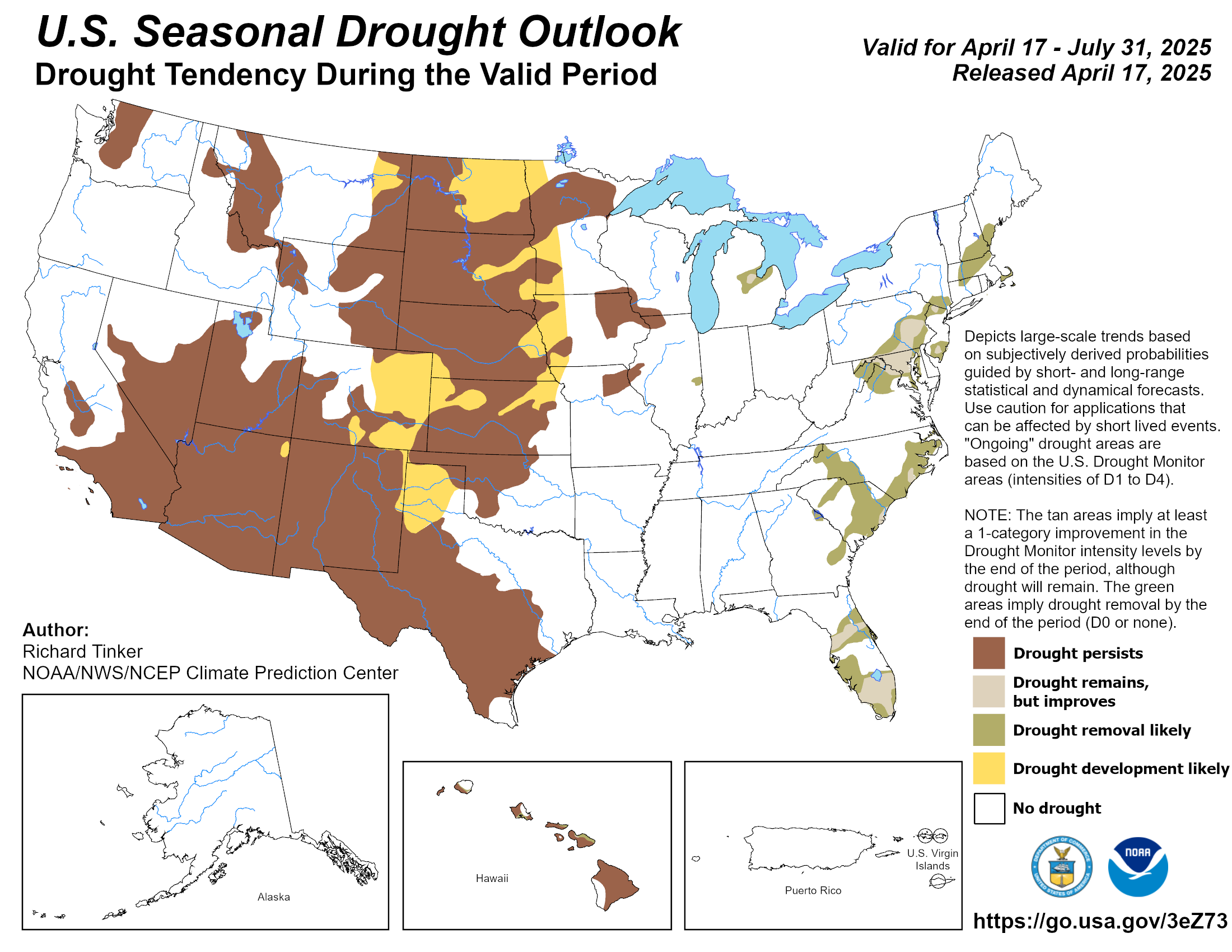
Seasonal Drought Tendency

Percent of Precip for the Year


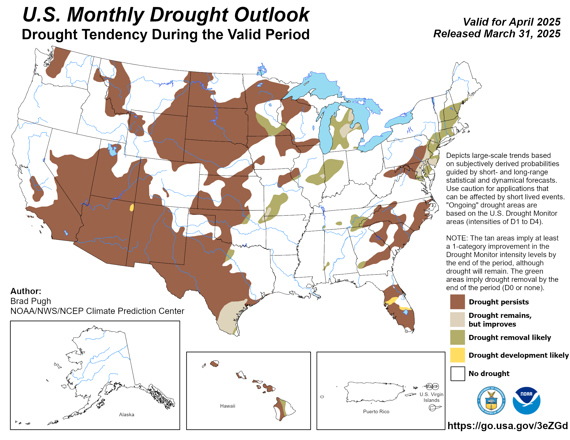
Monthly Drought Tendency

Percent of Precip for the Year


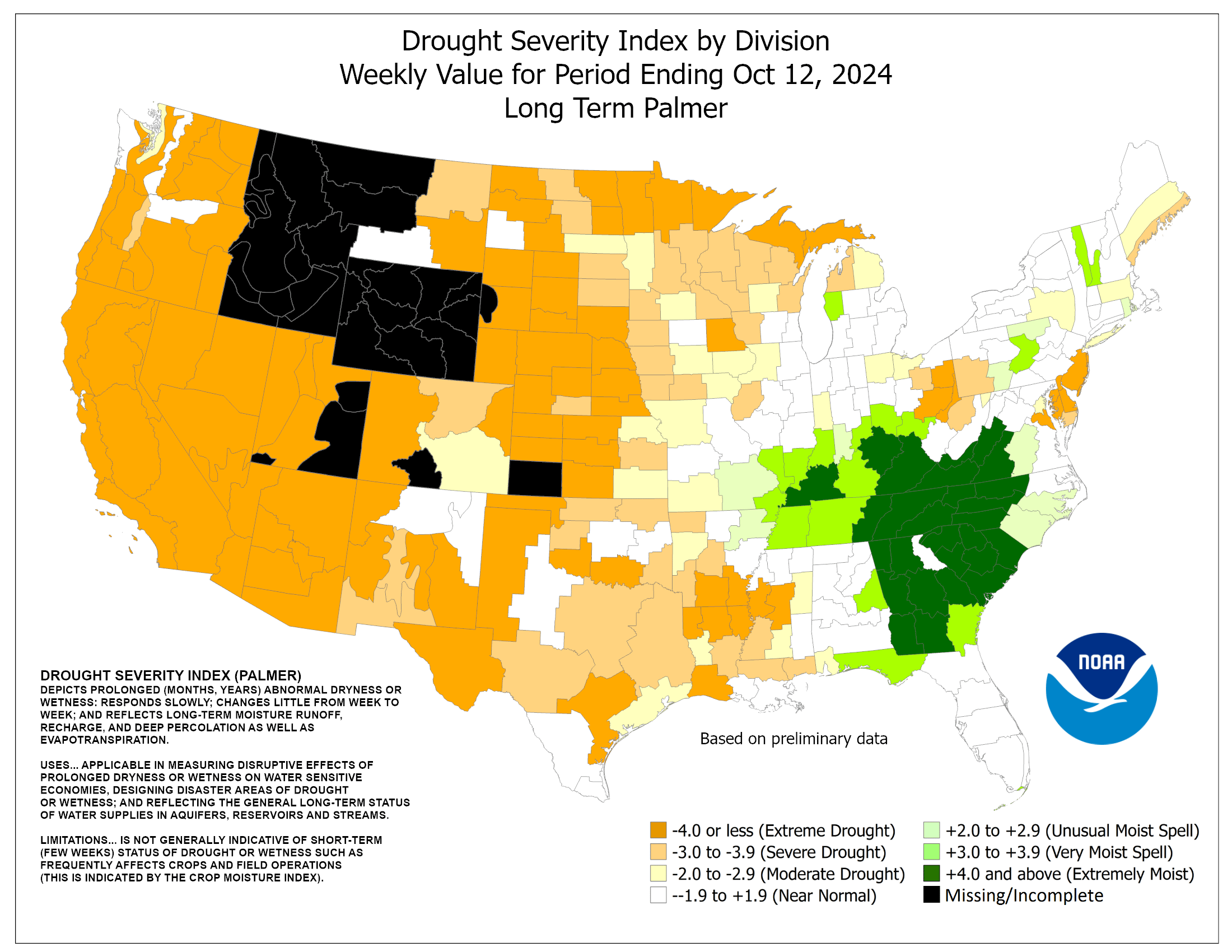
Palmer Index

Palmer Index


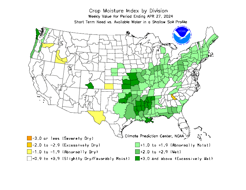
Crop Moisture

Crop Moisture


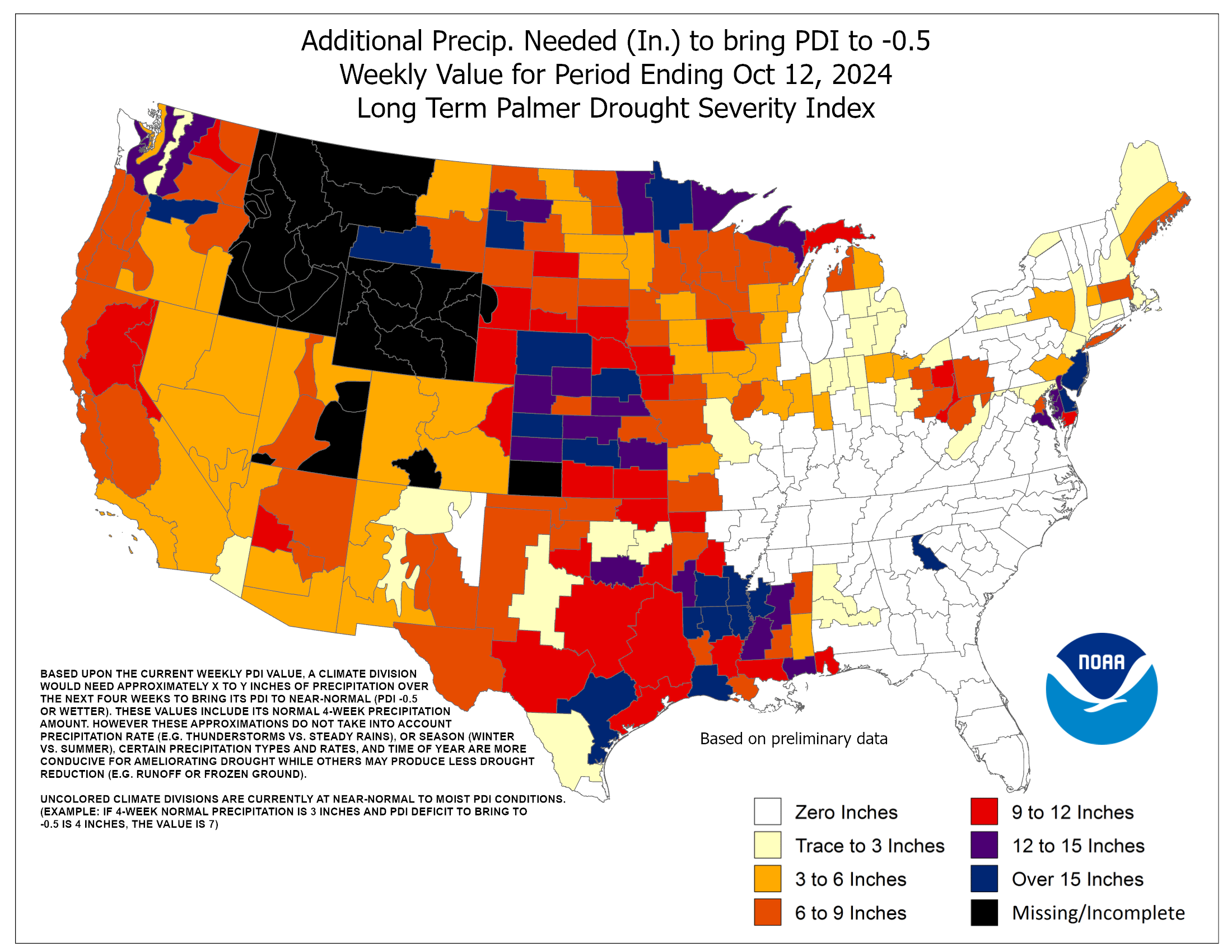
Precipitation Needed to End Drought

Precip Needed to end Drought


Weekly Weather and Crop Bulletin PDF


Images and Data from UNL Drought Monitor, the USDA, and the NWS Climate Prediction Center.
Web Page Created by Dacula Weather and Modified by SE Lincoln Weather.

Top | Contact Us

free counters
global visitors
Valid XHTML 1.0 TransitionalValid CSS!
© 2025, Southeast Lincoln Weather | Weather-Display (10.37S-(b152)) | Valid XHTML 1.0 | Valid CSS

This website is neither affiliated with nor endorsed by the National Weather Service or any other government agency. The weather data contained herein is offered without any warranties express or implied, and is meant to only supplement, not replace, official NWS weather forecasts and information.