
 Scan With Phone's Bar Code Reader
Select NOAA-NWS Forecast Office Text Products
(Product availability varies with seasons, forecast office, and weather.)
Hazardous Weather Outlook for Omaha, NE
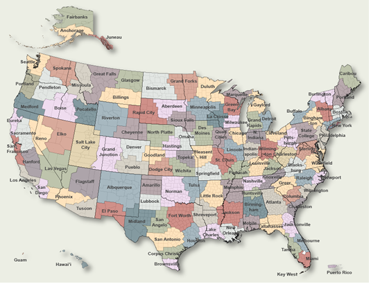
To Select Another NWS Office Click on Map or Choose from List
|
| Select Forecast Office: | Select Product: |
634 FLUS43 KOAX 130125 HWOOAX Hazardous Weather Outlook National Weather Service Omaha/Valley NE 825 PM CDT Thu Mar 12 2026 IAZ043-055-056-069-079-080-090-091-NEZ011-012-015>018-030>034- 042>045-050>053-065>068-078-088>093-140130- Monona-Harrison-Shelby-Pottawattamie-Mills-Montgomery-Fremont-Page- Knox-Cedar-Thurston-Antelope-Pierce-Wayne-Boone-Madison-Stanton- Cuming-Burt-Platte-Colfax-Dodge-Washington-Butler-Saunders-Douglas- Sarpy-Seward-Lancaster-Cass-Otoe-Saline-Jefferson-Gage-Johnson- Nemaha-Pawnee-Richardson- 825 PM CDT Thu Mar 12 2026 This Hazardous Weather Outlook is for southwest Iowa, west central Iowa, east central Nebraska, northeast Nebraska and southeast Nebraska. .DAY ONE...Tonight. Extreme Fire Danger continues through this evening. Strong winds will gust up to 40-50 mph out of the west this evening, then out of the northwest tonight behind a cold front. Red Flag, High Wind Warnings and Wind Advisories are in effect. .DAYS TWO THROUGH SEVEN...Friday through Wednesday. Another round of strong winds and wintry weather (60-80% chance) are expected to impact the region Saturday night into Sunday. .SPOTTER INFORMATION STATEMENT... Spotter activation is not expected at this time. $$ |
Previous Hazardous Weather Outlooks may be found at
NWS Omaha, NE (OAX) Office Hazardous Weather Outlooks.
(Click 'Previous Version' there to view past versions successively.
Some may differ only in time posted.)
Products Courtesy of NOAA-NWS
NWS Information Parsing Script by Ken True at Saratoga Weather - WFO and Products Scripts by SE Lincoln Weather.
Mapping by Curly at Michiana Weather and by Tom at My Mishawaka Weather.


